Oceans cover more than 70 percent of the globe and nearly three billion people depend on marine and coastal biodiversity for subsistence. However, marine funds still hold many mysteries for human beings.
In recognition of the crucial importance of marine ecosystems for the development of human life, and with the goal of involving more institutions and society in order to achieve greater knowledge and protection of them, the UN proclaimed the period from 2021-2030 as the Decade of Ocean Science for Sustainable Development. The official launch of the decade will take place at an event in Berlin in May, which will be one of the biggest events of the 2021 international green agenda. In anticipation of the occasion, in order to start to whet your appetite, we have compiled some great moments in the history of the exploration of the seas and oceans. If everything goes according to plan, in the coming years, many more could be added to this list.
Ancient Greece: from the origin the word “ocean” to the tides
Oceanus (Ώκεανός in ancient Greek) was the name of a Greek god, the son of Uranus and Gaia, and the personification of what the Greek considered was a huge mass of circular water that surrounded the Earth.
We also have the Greeks to thank for the term “ocean”, due to some of the first discoveries in the history of geography in general and oceanography in particular. If Pythagoras is credited for discovering that the Earth is round, and Eratosthenes for calculating the Earth’s circumference and inventing the concepts of geographical latitude and longitude, the relationship between the tides and the movement of the moon was discovered for the first time by the explorer Pytheas (4th century BC).
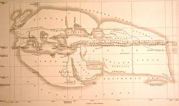
There is life past 4,000 meters
The Challenger expedition, which took place from 1872 to 1876, represented a great step forward in terms of our understanding of the oceans, and laid the foundations of oceanography in several respects. Charles Wyville Thomson was the Scottish naturalist who led the research.
The boat departed from Portsmouth, England on December 21st, 1872, covering nearly 130,000 kilometers and cataloging over 4,000 new species during the journey. It also confirmed the existence of life at 4,389 meters below sea level. This discovery shattered the previously held belief that stipulated that marine life was not possible past 549 meters below sea level. It also verified the variation in temperature at the depths of the ocean, thus confirming the existence of ocean circulation.
Jacques Cousteau and scuba diving
Millions of people around the world discovered the wonders that existed under the surface of the oceans thanks to the French explorer and oceanographer Jacques-Ives Cousteau (1910 – 1997). Without a doubt, one of the greatest scientific discoveries of all times. It certainly deserves to be mentioned on this list due to the unprecedented interest his portrait of underwater life managed to peak among the general public.

But apart from his efforts to raise awareness, Cousteau left scuba diving as his legacy, together with the engineer Émile Gagnan. Baptized as aqua-lung, this system gave divers much more independence to explore the deep seas, as they no longer depended on the provision of oxygen from the surface. Cousteau himself was in charge of carrying out the first successful test of his invention in June 1943.
Mapping the surface of the ocean from space
On August 10, 1992, a satellite was launched into space that was trascendental for ocean research. TOPEX/Poseidon, the result of collaboration between NASA and CNES (the French space agency), was fundamental in obtaining data that was previously inaccessible regarding the ocean surface, or sea level, from different points of the globe.
Oceans absorb a vast amount of the Earth’s heat that comes from the sun, making measurements of the ocean surface key for a correct understanding of the effects that ocean current patterns have on the climate. They are also a tool to study other fields like coral reefs, hurricane prediction, navigation or fishing.
Challenge for 2030: completing a map of the ocean floor
Detailed knowledge of the sea floor could be key to taking the necessary measures for its conservation, as it allows for better understanding of certain fundamental processes such as ocean circulation, climates and rising sea level, but also sediment transport and the spread of tsunamis, among other things. However, as of the year 2017, just six percent of the sea floor had been mapped with modern standards. The project Seabed 30, backed by more than 100 international organizations, was established to address this blank map of the deep seas. In June 2020, it was announced that in its three years of existence it had managed to map 19 percent of the deep seas, nearly one-fifth of its entirety. The goal is to reach 100 percent by the year 2030.
Comments on this publication