Alejandro Román, a researcher at the Institute of Marine Sciences of Andalusia, is co-author of the first repository of photogrammetric data captured with unmanned aerial vehicles in the Antarctic, which the CSIC has published as a valuable source of open access information, given the difficulty of accessing these remote regions. He calls for the protection not only of this area, but of the environment as a whole.
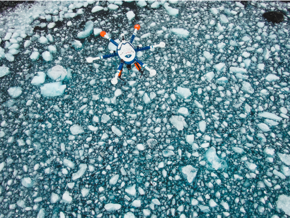
Alejandro Román (Sanlúcar de Barrameda, Cádiz, 1996), a researcher at the Institute of Marine Sciences of Andalusia (ICMAN-CSIC), has found in drones the intersection between his father’s passion for aviation and his own personal interest in dealing with marine environmental phenomena from a more multidisciplinary perspective. With a degree in marine sciences and a masters in oceanography from the University of Cadiz, he has been working with unmanned aerial vehicles since his undergraduate thesis, but in a more intense and focused way during his doctoral research at ICMAN-CSIC. Together with Antonio Tovar and Gabriel Navarro (his thesis supervisors and “my two great sources of inspiration,” as he puts it), he has just published the first open-access repository of photogrammetric data collected in up to 28 drone flights during the second Antarctic campaign of the PiMetAn project, between January and March 2022, on Deception and Livingston Islands.
“This first public dataset contains information to characterise the Antarctic ecosystem and its functioning,” says Román, adding that it is a valuable resource for polar research in the face of the current climate emergency. Drones, he says, are an intermediate monitoring tool between in-situ sampling techniques and satellite remote sensing for areas of high ecological value, extreme climatic conditions, difficult access and potential risks to research personnel. Much of the cryosphere meets these requirements.
Román recalls that photogrammetric techniques have made it possible to generate topographic and orthomosaic products that have been successfully used to produce topographic maps of polar regions, censuses of birds and marine mammals, vegetation mapping, the study of glaciers and the monitoring of soils and geological structures.
“Antarctica, which plays a fundamental role in the Earth’s climate, in the regulation of ocean circulation and in the global ecosystem, is one of the regions most vulnerable to rapid climate change. It is a scientific challenge to understand how it works, in order to predict and prevent risks at both local and global scales.”
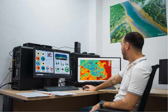
It goes without saying that technology plays a key role in the scientific field in which Román works. But it’s not just the flashy stuff of drones and sensors; it’s also the behind-the-scenes stuff: machine learning, programming languages and geographic information systems that convert the raw data collected into a format that users—environmental managers, decision-makers, scientists, the general public—can understand and manipulate. Artificial intelligence is also key, speeding up processes, optimising algorithms and improving the performance of some of the sensors that drones carry.
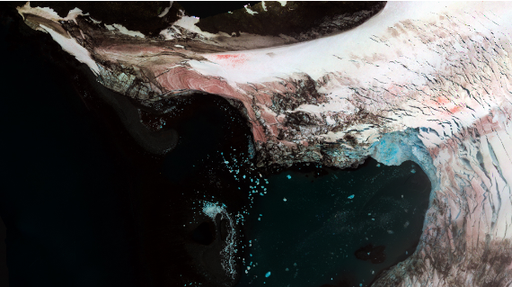
According to the data collected by ICMAN-CSIC drones in successive campaigns, there are clear signs of degradation in Antarctica, which plays a fundamental role in the Earth’s climate, in the regulation of ocean circulation and in the global ecosystem. It is also one of the regions of the planet most vulnerable to rapid climate change. For example, algae blooms are appearing more frequently on snow and glacier ice, with reddish or green patterns that are easily visible from the air, and contribute to reducing the albedo of the snow surface, which accelerates the melting process, says Román.
“Collaboration is fundamental in my field of research, and for this reason it is as important to network as it is to publish your work in order to grow professionally. During the three and a half years of my doctoral thesis, I have been fortunate to collaborate with exceptional groups in institutions all over the world.”
“It is a scientific challenge to understand how they work in order to predict and prevent risks at both local and global scales,” says Román. The consequences on a planetary scale, which are in many ways unknown, could range from a contribution to sea-level rise to possible changes in ocean circulation patterns. “We could have a big problem for the whole planet,” he warns.
This researcher has not yet been able to travel to Antarctica. When the first opportunity arose, there were staffing restrictions due to the recent outbreak of the coronavirus pandemic; the second opportunity came just after he had landed at the University of Maryland Center for Environmental Science (United States) for a seven-month stay with a Fulbright Scholarship, a “unique” experience from which he returned in February and which has helped him to grow professionally and personally.
On the technical side, while in Maryland he worked on a research project to develop an open-source algorithm to address the major limitations of drone surveys in observing local phenomena on the water surface. On the experiential side, he has “the wonderful people” he met there and the drives through the US national park network. “It has helped me to appreciate my work more, to believe in myself more, and also that those who work hard will always find their reward in the end, one way or another,” he says.
“Climate change must be a priority for everyone. We can already see some of the consequences. I don’t have to go very far. I grew up with Doñana on the opposite bank, and I see how it is drying up and how fewer and fewer birds are crossing during the migratory season.”
Perhaps it has also reinforced the taste for teamwork that he brought with him from home. Working with “exceptional groups” in institutions all over the world has allowed Román, for example, to make the leap to other remote sensing tools such as satellites or field spectroradiometry. Today, he collaborates mainly with his “neighbours” at the University of Cádiz and, on the international scene, with colleagues at the University of Nantes (France) and NASA Goddard Space Flight Center (USA).
Román would like to set foot in Antarctica one day. He does not think the message should be that it is important to protect it, but rather “to protect the environment and all the life that derives from it,” he says. To do that, more people need to be aware. “Less words and more action,” he says.
Comments on this publication