In the last 50 years, more than two-thirds of our planet’s wildlife has disappeared, largely due to habitat loss, overexploitation and anthropogenic climate change. While biodiversity is declining globally at a rate not seen in millions of years, high technology, on the other hand, is advancing more rapidly than ever, enabling a growing community of scientists and conservationists to use cutting-edge tools to monitor and study the wildlife that remains. We look at six ways that high technology is being used in ecological research and conservation.
Deep neural networks
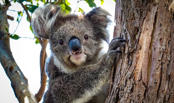
Given that human intelligence has proven insufficient to wisely manage the natural world, It is perhaps not surprising that ecologists are increasingly turning to artificial intelligence (AI) as a tool in the feverish race against time to conserve nature. One of the areas in which humans need the most help is in categorising the millions of digital photos taken by motion-sensor “camera traps” placed in natural habitats. These cameras provide an unobtrusive means for ecologists to gather vast amounts of data on the number, location and behaviour of animals in the wild. Manually reviewing all the photos has so far been a tedious, time-consuming and expensive task for ecologists, who have relied on crowd-sourced teams of volunteers. AI algorithms called deep neural networks are now able to automatically identify, count and describe wild animals in camera-trap images with the same level of accuracy as humans, but at a fraction of the time and cost, allowing ecologists to spend their time on more important tasks.
These deep neural networks are trained by looking at thousands of camera-trap photos that have already been tagged, which can be a problem when the animal is so rare that few photos exist. Researchers in Scotland are trying to train AI to identify critically endangered Scottish wildcats using images of captive animals, a task that is proving challenging.
In addition to visual classification, deep neural networks are also being applied to acoustic recordings of insects, birds and mammals. Passive acoustic monitoring, combined with machine learning, has been used, for example, to automatically detect and monitor bat populations through their echolocation calls, identify the calls of the endangered North Atlantic right whale in an attempt to reduce collisions with ships, and collect data on the endangered African forest elephant. Researchers at Oregon State University have developed a deep neural network that can identify sounds made by 14 different bird and mammal species, work that was driven by the need to monitor threatened spotted owls without capturing them.
Satellite imagery
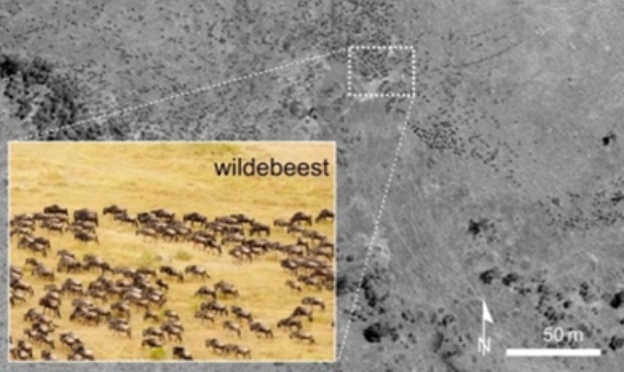
Wildlife does not respect international boundaries and our environmental problems are ever more global in their scope. For this reason, space-based observation technology is becoming increasingly important for providing critical information about wildlife and the threatened ecosystems it inhabits. High-resolution satellite imagery is being used to detect illegal fishing and mining, map the world’s coral reefs, monitor desertification and deforestation, and locate and count large animals such as whales, elephants, walruses, seals and albatross, which live in remote, inaccessible or difficult to monitor areas. In 2020, scientists discovered 11 new emperor penguin colonies and breeding sites from satellites in space by looking for guano stains on the ice. Satellite imagery is also making it possible to identify beached whales in places they would otherwise go unnoticed.
Tracking wildlife from space
Scientists have been using satellite-based tracking tags for decades to collect and communicate the location of animals. The two most common systems are ARGOS (Advanced Research and Global Observation Satellite) and GPS (Global Positioning System). The ARGOS system, in use since the 1970s, uses tags that transmit location data to polar-orbiting satellites as they pass overhead, which relay the information to a data processing centre on Earth. Since ARGOS tags must transmit to outer space, they require a powerful battery and thus have traditionally been used with larger animals such as polar bears, elephant seals or tiger sharks. However, thanks to improved battery technology and miniaturised transmitters, modern ARGOS tags are now light enough to be placed on birds, some 4,500 of which are tracked each month.
In contrast, GPS tags do not transmit a signal, but receive data from a network of satellites to determine the animal’s position. This can be transmitted wirelessly to a cellular tower or handheld unit, or in remote areas where cellular connectivity is unreliable, to satellites. The latest tracking tags are also fitted with sensors that can measure the animal’s health, fertility and temperature, just like fitness trackers for humans. Similarly, in the case of marine creatures, they can record data such as water temperature, pressure (to calculate depth) and light levels.
The ICARUS (International Cooperation for Animal Research Using Space) Initiative is an Internet of Things system designed to track the migratory patterns of small flying animals using GPS tags and tiny radio transmitters. The signal is received by an antenna on the International Space Station (ISS), which is only 350 km from the surface, compared to 850 km for ARGOS satellites. These transmitters, which are solar-powered and only transmit when the ISS is overhead, weigh just a few grams, but researchers anticipate that future tracking devices will be light enough to attach to a honeybee, monarch butterfly or desert locust.
Drones that count animals
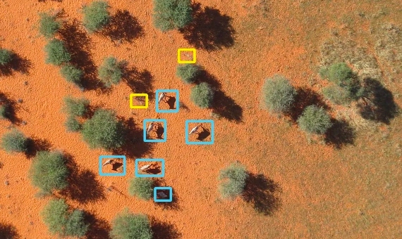
Although wildlife surveys have been conducted in aircraft for years, the use of remotely piloted aircraft, commonly known as drones, has become an increasingly powerful and popular tool for wildlife ecology. They are used especially for data collection and population surveys, as drones count wildlife with greater precisely and accuracy than humans. These devices are particularly suitable for collecting data on animals congregating at breeding and nesting sites, particularly waterbirds such as albatrosses, penguins, gulls, terns and egrets, as well as other animals such as sea turtles, seals and dugongs.
Using facial recognition to identify primates
Given the similarity of human faces to those of our primate cousins, it should come as no surprise that researchers have explored the use of facial recognition technology to identify primates individually, which would allow them to address fundamental questions of ecology, behaviour and conservation. At the University of Oxford, researchers have used a 14-year longitudinal archive of video footage of wild chimpanzees to train an artificial intelligence to accurately detect and track individual chimps using facial recognition. This will allow researchers to use their vast collections of decades-old video data to analyse chimp behaviour over multiple generations. Elsewhere, Chinese researchers have designed a deep neural network that can automatically identify individual primates from 41 different species with 94.1% accuracy.
Meanwhile, in Indonesia, WWF is using facial recognition technology to identify and track individual orangutans from images captured on camera traps. The system requires about 30 images to train the AI to recognise each orangutan, a species of ape whose numbers are declining precipitously due to habitat destruction.
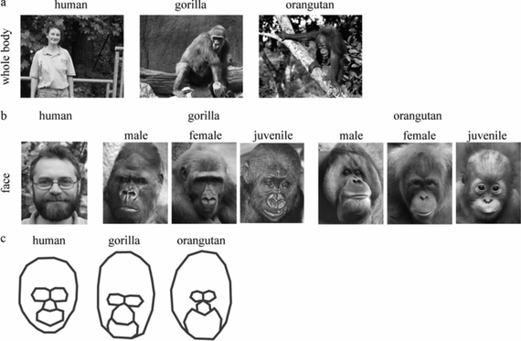
Facial recognition technology has also been used to identify other mammals such as lions and pandas, and should eventually be able to identify virtually all mammals through their unique facial features.
Measuring biodiversity by sniffing the air
By analysing air samples from inside a zoo, Canadian researchers have discovered that they can identify the presence of nearby animals through their DNA floating in the air. While collecting environmental DNA is a widely used approach to identify species in aquatic ecosystems, we now know that the technique also works on land, opening the door to a potentially non-invasive way of monitoring terrestrial biodiversity. Airborne DNA from animal skin cells, saliva, hair and other sources can be detected several hundred metres from the source, even after the animal has left the area. This make it one of the few bio-monitoring techniques that does not require the presence of the animal, like a footprint.
Comments on this publication