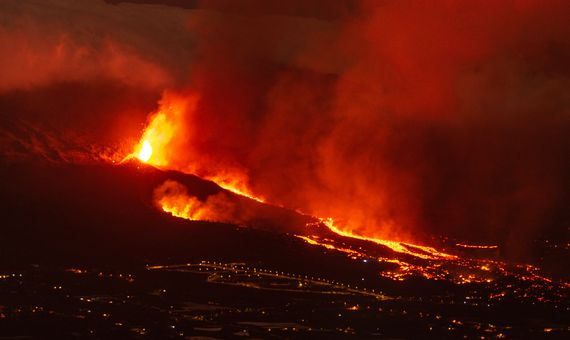
An erupting volcano is both a natural catastrophe and a spectacle of rare beauty, but the former often prevents us from enjoying the latter. We cannot silence volcanoes, but science is now searching for ways to predict these phenomena so that the harm they cause to people and property can be avoided. Given the immense human losses caused by earlier eruptions, when no predictive tools existed, progress has clearly been made. But more recent eruptions such as those of the Cumbre Vieja volcano on the Canary Island of La Palma, Mount Etna in Sicily or Fagradalsfjall in Iceland serve to remind us that we do not yet have the necessary science to make detailed predictions.
The most tragic example of what volcanic eruptions were like in times past occurred on 10 and 11 April 1815, when the summit of Mount Tambora—a 4,300-metre-high peak on the Indonesian island of Sumbawa—erupted violently. Magma ravaged nearby villages, claiming 60,000 lives (according to a conservative estimate). The collateral effects were felt across the globe. The year following the catastrophe, 1816, would be remembered as “the year without a summer“ because the cloud of gases emitted by the volcano over the following months blanketed the atmosphere, causing global cooling and ruining crops. Far away from the volcano, in Europe, the consequences of this mini-climate change were famine, violence and the looting of farmers’ grain silos. A huge crater 6.5 kilometres across and one kilometre deep bears witness to the disaster today, more than two centuries after Tambora’s eruption, the most powerful in recorded history.
“Maybe today we would have prevented those deaths,” Stephen Self, a volcanologist at the University of Berkeley, told OpenMind. “The volcano would be monitored and that would give us weeks or months to evacuate the population.” Two centuries later, the science and technology to predict when a volcanic catastrophe will occur has evolved radically, as evidenced by the warnings that made it possible to alert the population of La Palma living in a risk zone. In 2015, the Global Volcanic Hazards and Risk report, produced by the Global Volcano Model and the International Association of Volcanology and Chemistry of the Earth’s Interior, estimated that these advances have saved at least 50,000 lives over the last century.
The key to this progress lies in basic science and technological innovation. On the theoretical side, modelling the complex physical processes that take place inside a volcano has enabled the development of ever-evolving statistical prediction models. And at the technological level, the addition of numerous means of telemetry has refined the accuracy of predictions, which experts compare to the medical diagnosis of a disease: “As in the case of health, a single symptom is not enough,” Self explains. “We need to compile and correlate data on the variation of ground deformation, seismic activity and chemical emissions.”
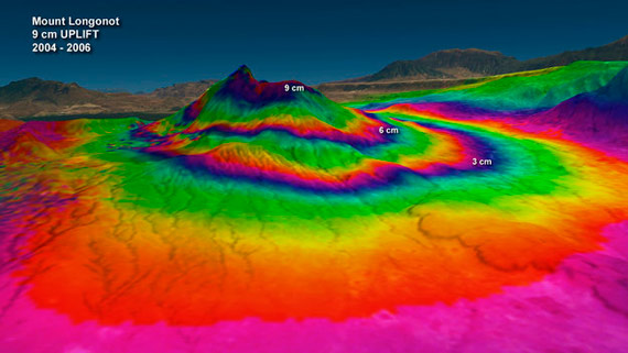
Satellites have reinvented how this data is collected. One of the main signs that a volcano may be at risk of eruption is ground deformation caused by increased volcanic activity. The technique of Interferometric Synthetic Aperture Radar (InSAR) has allowed for huge advances by working in parallel with classic GPS. A satellite takes two consecutive photographs of the same area, separated by a few days. Then, using interferometry, the two pictures are superimposed to create a third image that shows the deviations of the ground to the millimetre: “We have to complement this with GPS, because a lapse of several days is not operationally adequate for the constant monitoring of a volcano,” explains Carmen López Moreno, director of the Central Geophysical Observatory of the National Geographic Institute of Spain. “With a GPS network, ground displacement can be measured at one or more specific points. The two techniques are complementary because InSAR provides data over large areas that can be correlated with those points.”
This ground deformation has to be combined with other symptoms to raise the alarm. One of them is seismic activity, and to detect it a network of high-precision seismographs has to be used to warn of earthquake swarms, small tremors (undetectable by traditional measuring devices) that are caused by the internal movement of fluids in the volcano, as has happened in the case of La Palma. Another key factor is the emission of gases—mainly SO2 and CO2—in abnormal quantities. Satellites again play a key role. NASA’s MODIS and OCO-2 are responsible for detecting anomalies in this parameter, which may indicate possible eruptions.
New techniques for predicting eruptions have been explored in recent years. The MU-RAY project uses muon radiography, which measures these elementary particles present in cosmic radiation that are able to penetrate the Earth, to obtain images of unprecedented resolution of the volcano’s interior, allowing changes in its density to be seen. This technique has already been used experimentally on Mount Vesuvius. Another avenue being explored is the study of infrasound—below the limit audible to the human ear—emitted by the activity inside a volcano.
Furthermore, the study of new eruptions also provides valuable clues that help the prediction process. By analysing rocks from the underwater eruption off the Canary Island of El Hierro in 2011-2012, a team of scientists from Australia, Chile and Spain has determined how monitoring certain volcanoes in so-called hot spots—such as those in the Canary Islands or Hawaii—can detect when magma reaches the base of the Earth’s crust, where processes leading to an eruption take place. According to the study’s first author, University of Queensland volcanologist Teresa Ubide, “this new information takes us one step closer to improving the monitoring of volcanic unrest, which aims to protect lives, infrastructure and crops.”
However, as University at Buffalo geologist Tracy Gregg wrote, each volcano has its own personality, and therefore its signs of activity do not define general rules of thumb for all volcanoes, but must be interpreted in the context of each volcano’s past eruptions. In the case of Kilauea in Hawaii, one of the most closely watched volcanos on the planet, its extensive monitoring has made it possible to predict its behaviour fairly accurately. However, the volume of data available is so immense that volcanologists are now looking to Artificial Intelligence technologies to improve the predictions.
Despite all these advances in research and technology, the effectiveness of predictions still has much room for improvement. The phase of volcanic unrest that precedes most eruptions only culminates in an eruption one out of every two times (47%) and extends for an average period of 500 days, with symptoms increasing abruptly hours before the eruption. More seriously, according to the Global Volcanic Hazards and Risk report, only 35% of permanent observatories have adequate technical and scientific capacity to monitor volcanoes. The report also predicts that the likelihood of a violent eruption like that of Mount Tambora occurring in the 21st century is about 33%.
For volcanologist Stephen Self, the remedy is clear: “Money. Money is still the main constraint for countries with high volcanic risk not to fund an observatory. And this also restricts research, because we need to monitor more eruptions to know what the determining factor is in order to define our predictions.” The detailed study of the forthcoming eruptions will serve to improve the prediction technology and statistical models theorizing volcanic activity. It will be another step on the scientific path to “taming” volcanoes, or at least learning to live with them. Eruptions will continue to be wild and inevitable natural phenomena, but understanding and predicting the behavior of volcanoes allows us to be prepared for the next Tambora and continue saving lives.
Comments on this publication