What will the cities of tomorrow be like? Back in the 90s, many scholars speculated about the ongoing digital revolution’s impact on cities, and the possibility of replacing physical space with virtual space, or atoms with bits. They fantasized about the dark, sexy image of disappearing urban spaces inhabited by individuals who would lead a mostly virtual life in cyber space, engaging in digitally encoded interactions rather than face-to-face communication.1 Enthusiasts of digital technology pushed the envelope to the extreme by announcing the official death of history, space, time, geography, and cities, among other things. The mainstream view was that digital media and the Internet would kill cities in the same way that they had killed distance. Technology writer George Gilder proclaimed that “cities are leftover baggage from the industrial era,” and concluded that “we are headed for the death of cities” due to the continued growth of personal computing, telecommunications and distributed production (Peters and Gilder, 1995). At the same time, MIT Media Lab’s Nicholas Negroponte wrote in Being Digital that “the post-information age will remove the limitations of geography. Digital living will include less and less dependence upon being in a specific place at a specific time, and the transmission of place itself will start to become possible” (Negroponte, 1995).
Yet, it became apparent in the years following the first wave of enthusiasm about digitality, that this was not the destiny of either our digitally enhanced race, or the constructed spaces and landscapes that accommodate our activities. Cities and the constructed spaces that they contain have been multiplying at an unprecedented rate, and the spatial production and consumption of mankind still fall very much within the physical realm. In fact, cities have never prospered as much as they have in the past couple of decades. For example, China is currently building more urban fabric than humanity has ever constructed in one era. And a particularly noteworthy moment occurred two years ago: for the first time in history, more than half the world’s population—3.3 billion people—lived in urban areas.3
Thus, despite a generalized obsession with the vision of an all-digital world, a new situation has emerged where the digital and the physical world are merging, and atoms are augmented by bits of information. The digital did not and will not kill the physical, as fantasized during the 90s. In fact, the digital and the physical are recombining, or, in the words of Hiroshi Ishii: “The bits and bricks are marrying.”4 A layer of networked digital elements blankets our built environments, blending the information sphere and the physical space inhabited by contemporary subjects in a seamless way.
What are the consequences of such transformations? This question can be addressed on several levels. In this article we will focus on one particular aspect that we have found most productive: the transformation of our cities into cybernetic, real-time control systems with a combined static and dynamic nature that consists of things that exist in the material sphere, and things that happen in the info-social sphere.
What follows is a speculation on the factors that will most significantly contribute to the birth of this new generation of urbanity. Our cities of the near future will operate as cybernetic systems that function via sentient control mechanisms. With a plethora of possibilities in telecommunication, people who live in digitally augmented cities will benefit from real-time access to vast repositories of information. And, with the aid of new sensing and actuating technologies, all constitutive elements of urban living will be transformed into context-aware, decision-making entities. In such intelligent environments, people will be able to be incorporated as entities with transient desires, needs and preferences: hyper-individualized “users” as opposed to generic “inhabitants.”
We will conclude by speculating about the new generation of denizens that are to inhabit these cities: user-inhabitants who are digitally augmented and well informed about the dynamics of the cities that they inhabit. In other words, we will focus on how people who are environmentally digitally enhanced start acting like sensors in their own right, actuated in a real-time feedback mechanism between the city and themselves, and mediated with the aid of new digital technology and telecommunication networks, while the city itself is the interface for such mediation.
The City as a Cybernetic, Real-Time Control Mechanism
In his 1969 article “The Architectural Relevance of Cybernetics”, Gordon Pask proposed that architectural spaces should be designed as systems capable of responding to emerging conditions, and adapting to the needs of their inhabitants (Pask, 1969: 494-496). To this effect, he compared such spaces to cybernetic systems. Following the same line of thought, we may conceive of the digitally enhanced, postmodern city as a cybernetic mechanism that accommodates interaction in its capacity as a spatial system capable of extracting contextual information, acknowledging the inhabitants’ desires and needs, and adopting behavior patterns based on what it learns.
Such a cybernetic urban system achieves its monitoring with sensing technology. It is conditioned through computational processes that are based on detected spatio-temporal changes. It is actuated through embedded virtual or physical agents that provoke changes detectable by the inhabitant, or that enhance the spatial experience of the occupant in an explicit or implicit way. It is also enhanced with memory of the past and anticipation of the future, and is endowed with some level of data connectivity, especially if the monitoring and actuating agents are physically separate and the distance needs to be technologically bridged. These steps imbue the city with a limited awareness of contextual change over time, and the capacity for responding to it accordingly.
In terms of sensing, cameras and microcontrollers are used ever more extensively to manage city infrastructure, optimize transportation, monitor the environment, and run security applications. Advances in microelectronics now make it possible to implement “smart dust” networks of tiny, wireless, micro electro–mechanical system (MEMS) sensors, robots or devices. Besides, we are witnessing an explosion in mobile-phone use around the globe. According to ITU World Telecommunication Indicators Database, more than four billion mobile phones were in use worldwide by early 2009. Across socioeconomic classes and five continents, mobile phones are ubiquitous: they allow us not only to communicate with each other in unprecedented ways, but to create a pervasive sensing network that covers the whole globe.
In terms of regulation and actuation, the city already contains actuators such as traffic lights, remotely updated street signage, etc. More profound actuation is relatively problematic: for instance, we cannot double the size of a street in real time if we detect traffic congestion. However, unlike other real-time control systems, cities have a special feature: citizens. By receiving real-time information, appropriately visualized and disseminated, citizens themselves can become distributed, intelligent actuators who pursue their individual interests in co-operation and competition with others. Processing urban information captured in real-time and making it publicly accessible can enable people to make better decisions about the use of urban resources, mobility, and social interaction.
Figure 1. How can a city perform as an open-source, real-time system? MIT SENSEable City Lab Vision Poster

This feedback loop of digital sensing and processing could begin to influence various complex and dynamic aspects of the city, improving the economic, social, and environmental sustainability of the places we inhabit. Feedback loops could grow inside one another: buildings and other spatial devices throughout the city could become probes and ambient displays, but also evolve into real-time, responsive devices in their own right.
A cybernetic city operates on the logic of a hybrid computing paradigm that examines the ramifications of installing sensors that detect changes in the physical properties of the context; examines how an embedded microprocessor or computer processes the resulting digital signal; and finally examines how the system activates a series of actuators installed, embedded, or situated in the space. At times, the microprocessors act in isolation. Yet, once these micro-systems are networked, communication, sensing, and information-processing will disappear into the environment to create an Internet of Things with world-wide coverage, as in the idea of Ubicom proposed by Mark Weiser.5 One consequence of this dual process of sensing and actuation within the contemporary city is particularly important: cities can start to work as real-time control systems, regulated by a number of feedback loops. In the text that follows, we would like to focus on the possibilities of sensing and actuation in the cities of the near future.
The Cybernetic City and its Different Mechanisms of Sensing
In his Traité des Sensations, Étienne Bonnot de Condillac offers an interesting reflection on sensibility as the source of subjectivity.6 He imagines a living statue, devoid of any sensations but the sense of smell. He walks the reader through a sequence where sensation leads to comparison, which leads to judgment, which leads to reflection and reasoning, which leads to abstraction: the sum of all of the above results in what can be characterized as understanding and [human] agency. This sensationalist approach can be applied to cities as cybernetic mechanisms. Sensors are devices capable of registering one or more quantifiable aspects in the contexts where they are used. Once populated with large number of sensors and endowed with the capacity to register changes in its context, a city can acquire a limited level of agency through comparison, judgment, reflection, reasoning and abstraction.
To reach this goal, we should ask ourselves, how can we sense a city and its dynamics? One approach is to leverage systems already in place that have been developed for other reasons, but can function as a source of information on how our cities operate. A great example is the cellphone network. We define this as viral sensing, since the computational algorithms of such sensing practices install themselves on the digital networks that already augment cities, much like a virus settles in an already-operational environment within another organism in order to support its internal bio-processes. The premise of such sensing practices is that the contemporary subject voluntarily and involuntarily leaves digital traces on various networks that are juxtaposed over urban areas. Every time a credit card is used, a text message or an email is sent, a Google query is submitted, a phone call is made, a Facebook profile is updated, a photo is uploaded or tagged on Flickr, or a purchase is made on a major, on-line store like Amazon.com, an entry with the time and location of this action is added to a dataset on a central server, administered and maintained by the organizational entity providing the platform for these, and hundreds of other day-to-day operations. Once the datasets are spatially and temporally attached to entities and phenomena in the physical terrain, the urban landscapes that accommodate these traces are transformed to info-scapes. An info-scape, in this sense, is a digital terrain both temporally and spatially associated with the physical terrain. Info-scapes can be delivered on publicly used, architecturally installed digital screens, and personal, handheld computing units.
Figure 2. Wikicity Rome, 2007. MIT SENSEable City Lab: Assaf Biderman, Francesco Calabrese, Kirstian Kloeckl, Carlo Ratti, Bernd Resch y Andrea Vaccari
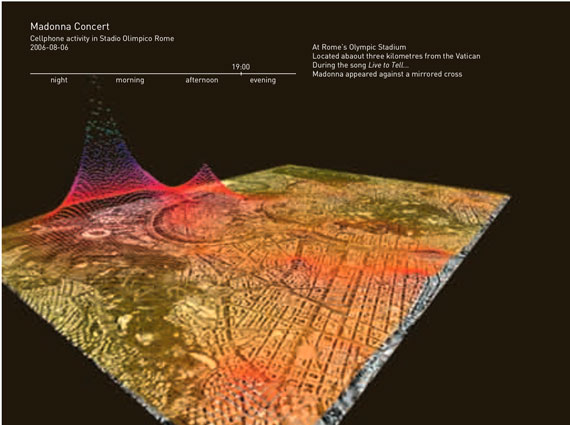
With advancements in the field of data connectivity and telecommunication technologies, connection to the aforementioned datasets of distant servers is improving, allowing data management engines to get real-time updates on the state of the monitored entities. The urban spaces of digitally annotated terrain augmented with mined datasets create mediated landscapes that allow for new forms of expression, such as public or museum exhibitions, or urban demos. For example, MIT SENSEable City Lab has conducted numerous experiments that led to such exhibitions and urban demos over recent years, some examples of which are Wikicity Rome and NYTE. In both cases, the real-time visualization of data mined from communication networks is cross-referenced with the geographical terrain, to allow for revealing urban dynamics in real-time to observers. Such technologically enhanced spectacles—real-time info-scapes projected onto architectural surfaces, or accessed via worn and handheld devices—provoke a temporary displacement of the observer from the physical terrain he/she inhabits to a distant location, providing him/her with a overview of the dynamics contained within the urban landscape.
The Wikicity Rome project tapped into aggregated data from cellphone usage. The resulting visualizations depicted the pulse points of the city, providing an overview of how the urban landscape is occupied, and where and in which temporal patterns the cellphone-using crowd is dispersed. Crowd sensing based on cellphone usage allows for spotting the hot locations and congested spots of the city in real-time. This can help administrative agencies to regulate traffic and the flow of resources within the city, based on real-time dynamics.
When the system was exhibited at the 10th International Architecture Exhibition of the Venice Biennale, researchers at MIT SENSEable City Lab also supplemented the resulting, cellphone-based evaluation of urban dynamics with data based on the instantaneous positioning of buses and taxis. This provided information about mobility, ranging from traffic conditions to the movements of pedestrians throughout the city, in real time. The visualizations provided a qualitative understanding of how the aggregated data of network cellphone usage and public transit locationing information can be used to provide valuable services to citizens and authorities. Researchers at MIT SENSEable City Lab believe that such information “can give city dwellers a deeper knowledge of urban dynamics and more control over their environment by allowing them to make decisions that are more informed about their surroundings, reducing the inefficiencies of present day urban systems” (Calabrese et al, 2010).
Aside from tapping into existing networks, customized sensor networks can also be implemented to decode various flows within the cities. The cybernetic city can receive its input from different networks of sensing mechanisms. The first is a network of centrally managed sensing agents, embedded within the fabric of the city. To this effect, smart dust saturates the space of urbanity, extracting large amounts of information about the processes contained within the built environment and constructed spaces, and channeling it to a central control and command mechanism. From there, this data is aggregated, managed, and used as the basis for how the monitored space of the city should be regulated and actuated.
The technology to geo-localize the whole surface of the world is not that far from becoming a reality. At this point, Google Maps API offers a two-dimensional, virtual model of the world. With advancements in the Google Earth API and platform, this virtual model is moving towards a fully realized, three-dimensional, virtual copy of the physical world. Imagine a day when such a model is augmented with geo-localized layers of information about each and every object it contains. This scenario would have two different but closely-related impacts on our consumption and production of space. First, the data extracted from all things would allow spatial practitioners to make sense of the dynamics of our constructed landscapes by analyzing these large, real-time data sets. This real-time knowledge of spatial dynamics could be fed back into the process of spatial design and the management of spatial resources. On the other hand, if access to such layers of information were democratized, then the inhabitants of our constructed landscapes would also benefit.
If a collectivity of sensors capable of communicating with a centrally managed server is embedded and distributed within a spatial context, the prospect of distributed sensing is shown as one aspect of a completely networked world, or an Internet of Things. If the sensors are well situated within the physical terrain, meaning that the digitally encoded transactions they send the server are annotated with their exact locations, this network allows a cybernetic system to create a virtual model of the physical terrain that is perpetually updated with real-time information about the context. Depending on the nature of the sensed data, the virtual model can represent different aspects of the physical terrain.
Sensor networks can consist of fixed sensor agents, or they can incorporate agents capable of navigating or probing the monitored terrain. If the sensors are embedded, they create a fixed backdrop for a virtual model of the monitored space’s real-time dynamics that corresponds to the permanent geographical location of the sensors. If the nodes are implemented as dynamic probes, this backdrop layer is also animated. In some cases, once the geographic locations of the sensors are coded, the only transmission required to update the virtual model is the sensor-detected change, and the unique identification code of the sensor transmitting the data. In the second category of mobile sensors, each transmission also needs to be tagged or annotated by the current location of the sensor.
Furthermore, a sensor network may be implemented so that the agents automatically report the current state of the monitored phenomena at pre-defined intervals, or so that agents report their current state in response to an update request from the central server aggregating the sensed information. This gives us the dichotomy of self-reporting sensor networks versus request-based sensor networks.
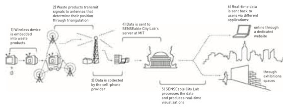
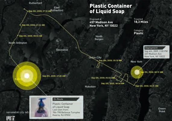
In urban sensing mechanisms that operate based on networks with central control-and-command structure, with algorithms that allow for the context-sensitive interpretation of the information transmitted to the database, we arrive at spatial scenarios where whole geographic regions are digitally augmented by the ubiquity of these sensor/transmitter devices. In the extreme version of this scenario, one can envision a world where any object is capable of sensing its context and reporting it back to a central data-management facility where its identity, its real-time location, and its contextual state are cross-referenced, stored, and managed computationally. A great example of such a scenario is the 2009 Trash Track project by MIT SENSEable City Lab.
The project consisted of digitally enhanced tags that could be attached to objects and could report their location to an Internet backbone infrastructure via cellular network. Trash Track made use of these location-reporting tags to track urban disposal and study the efficiency of the urban waste-removal chain. The platform allowed designers and planners to analyze the acquired data, and make well-informed, high-level decisions about how the given constructed landscape is managed. Therefore, a multiplicity of questions about the dynamics of the urban removal chain could be addressed empirically: Is our removal chain efficient? Is hazardous waste managed properly, or are there loopholes in our system that need to be taken care of? Is the recycled waste really recycled, or does it end up in dumps? The Trash Track system can have a great impact on the nature of the perceptual relationship that a city or region develops with its waste disposal habits.
Generally, people assume that once they dispose of waste, it is no longer their responsibility. Offering a real-time view of how the disposed items travel through the landscape of their daily lives will expand each citizen’s perceived sphere of responsibility from the domestic space, to the space of the city. Perhaps such real-time urbanity can result in a more responsible urbanity. Yet, Smart Trash is but one possible scenario in a more comprehensive conception of a world populated with sensors.
As previously discussed, in viral sensing, the involuntary digital footprints of contemporary urbanites stored in central databases of service providers is the basis for making sense of city dynamics. Again, sensor networks employ a top-down architecture where all the sensors report information from the environment to a central database, from where this information is aggregated, managed, and stored. Instead of such top-down approaches, we should also consider more grassroots, bottom-up systems for sensing the dynamics of cities. One possibility is thinking of each urbanite as a human sensor, an agent for sensing and reporting on his or her individual experience through tapping into data generated by user-contributed content on content-sharing platforms. Hence, we arrive at the third possibility of urban sensing: crowd-sourcing. User-generated content-sharing platforms allow everybody to report his or her experience to others in real-time, and in a multi-modal, high-resolution format. On these platforms, the users constantly project the physical world onto the digital world. Websites such as Flickr, Twitter, Facebook, and Wikipedia are repositories of what people “sense” in the city. This dynamic is gradually creating a digital world that mirrors the physical world. For almost every city in the world, a parallel digital version, as rich in diversity and content as its physical counterpart, is spread across different platforms and systems. This is because the digitally- augmented, contemporary urbanite uploads pictures of popular events, sends tweets about new happenings in real time, and creates and updates pages on Wikipedia about the city. These acts of communication generate different kinds of data that provide unique views on how people experience, navigate, and view the city. The crowd therefore becomes a distributed network of sensors that allows us to understand the dynamic patterns of the city and the experiences of its citizens at a quasi real-time rate. Hence, we call this phenomenon crowd-sensing (Pereira et al.).
Accessing the possibilities offered by user-generated content-sharing platforms, researchers at SENSeable City Lab have conducted various projects that focus on revealing the dynamic of civic landscapes, as viewed and collaboratively reported by their inhabitants. For example, in the Los Ojos del Mondo/The World’s Eyes project, the attractiveness and popularity of places and events are revealed by visualizing the density of user-generated data, in particular, the photographs tagged with information about their location and time uploaded by Flickr users. Then, user-generated electronic trails based on the sequences of photographs are used to reveal the presence and movement of visitors in a city. Such data visualizations that geo-localize the content generated by the user’s experience of a given urbanity reveal how cities are interpreted by their occupants—e.g., which locations are considered more or less important, and what is captured by the eyes of the people who are there. The “virtual city” created through the geo-localization of user-generated content reflects reality of the city dynamics, and can become a powerful resource for understanding these (Pereira et al.).
Figure 3. Trash Track, 2009. MIT SENSEable City Lab: Carlo Ratti, Director; Assaf Biderman, Assoc. Director; Dietmar Offenhuber, Team Leader; Eugenio Morello, Team Leader; Musstanser Tinauli, Team Leader; Kristian Kloeckl, Team Leader; Lewis Girod, Engineering; Jennifer Dunnam, E Roon Kang, Kevin Nattinger, Avid Boustani, David Lee, Programming; Alan Anderson, Clio Andris, Carnaven Chiu, Chris Chung, Lorenzo Davolli, Kathryn Dineen, Natalia Duque Ciceri, Samantha Earl, Sarabjit Kaur, Sarah Neilson, Giovanni de Niederhausern, Jill Passano, Elizabeth Ramaccia, Renato Rinaldi, Francisca Rojas, Luis Sirota, Malima Wolf, Armin Linke, Video
For example, an animation of the photos geo-tagged to different neighborhoods of Barcelona with descriptive tags that relate to “partying” in the summer of 2007, shows that Barcelona’s old town (Ciutat Vella) is where one goes to have fun. This observation is validated by the fact that the area contains both a high density of tourists, the Bohemian district of Gracia, and the Forum area (where various music festivals are held).
Another visualization in the same set looks at how Spain is photographed by tourists over the course of one year. While the photos overlap in certain locations and expose places that attract the photographer’s gaze, in other locations, the absence of images is eye-catching, revealing the more introverted parts of Spain.
Now that we have covered three different ways of providing input for the real-time control mechanism of a cybernetic city—viral sensing, implemented sensor networks, and crowd-sensing—we will move on to speculating about the output of such urban systems, or in other words, the actuation mechanisms.
The Cybernetic City’s Different Mechanisms of Actuation and Regulation
Parallel to mechanisms of sensing, mechanisms of actuating are integral to cities that are cybernetic systems. In terms of spatial actuation and regulation, we can speculate on two sets of possibilities. The first is regulating the landscape through actuator agents embedded within the space and controlled via algorithms that are conditioned by the information received from various sensing mechanisms. This vision opens up a multiplicity of possibilities for the design and implementation of responsive environments and interactive spaces by integrating digital technologies into the design of buildings and artifacts.
Actuators and information delivery interfaces are the components of the space controlled by the output of the operating system, based on changes registered by the sensors and reported to the operating system as an input. The actuation of a digitally augmented space can be considered in terms of provoking the type of physical motion we see in kinetic architectures. Motion-initiating agents can provoke rotation, vertical and horizontal disposition, or vibration in the elements of spatial settings that are of a substantive nature. Another possibility is to use materials that change shape when exposed to an electrical current. For example, depending on the pattern in which muscle wires are woven in to the fabric of an architectural surface, when an electrical current is applied, the surface changes form to accommodate the change in the length of the wires.
Once the inhabitable spaces of cities are transformed into context-aware, decision-making entities with the aid of sensing mechanisms that are also capable of analyzing the sensed data, the human subject inhabiting the space can be incorporated as an entity with transient desires, needs and preferences. This allows the environment to acknowledge its inhabitants’ input, or at least the specificities of their behavior. Inhabitants are then identifiable, each deserving specific treatment from the space he/she inhabits. A user-subject is a hyper-individualized inhabitant, and an interactive space respects the specificities of, and offers a customized experience for each one.
Physical locomotion is not the only way of initiating change within spatial settings. Change may also be invoked by manipulating the soundscape to inject the space with auditable [white] noise, or melodic and musical pieces that vary over time in terms of content, volume, and intensity. Perceivable change can be suggested visually, by light-emitting agents that vary in terms of intensity and color. Dispensing fog in different densities can also manipulate the visual aspects of the space by changing the depth of the perspectival field. Architectural surfaces can be endowed with variable visual characteristics, such as transparency or color, based on the amount of electrical current to which they are exposed. Furthermore, change may be evoked through digital screens embedded in architectural surfaces that deliver animated imagery to the subjects inhabiting the space. This is the case for the CLOUD display system. The patterns of its animated, spherical skins offer a civic-scale interface for delivery of real-time information to the inhabitants and visitors of the city.
Another example of display technologies that can actuate the space of the city is explored in the Flyfire project. Flyfire, a project by the SENSEable City Laboratory in collaboration with ARES Lab (Aerospace Robotics and Embedded Systems Laboratory), uses a large number of self-organizing micro-helicopters that contain small LEDs and act as smart pixels. The helicopters are controlled to create synchronized motions, and form elastic display surfaces. This allows for the transformation of any ordinary space into a highly immersive and interactive display environment. The proposed mechanism explores the possibility of a free-form spatial display that consists of a swarm of pixels that self-organize in real-time to adapt to the display requirements of any given scenario.
Space can also be suggestively manipulated in terms of thermo-ception. Actuators can provoke change in the environment through heating and cooling, or humidifying and dehumidifying mechanisms. Thermo-ceptory aspects of space can be conditioned using actuators such as fans that manipulate the pattern and intensity of air-flow through the space. Alternately, change can be expressed in olfactory terms by embedded, scent-emitting actuators that disperse patterns of odorous gases and liquids. In the extreme case, embedded liquid or gas dispensers will allow the designer to envision architectural settings that are of a less substantive or material nature, which is the case for the Digital Water Pavilion project.
Yet, manipulating space through embedded actuators is not the only possible means of spatially regulating cybernetic urban systems. The inhabitants of the cities themselves can be considered possible agents of regulation and actuation. From this point of view, the space of the city is envisioned as the provider of real-time access to information for a body that corporeally inhabits it. Hence, spatial design does not limit itself to the allocation of material resources, but takes into account the temporal allocation of information relevant to the specific location or context of those occupying it. The new analytical understanding of the spatial dynamics offered by the delivery of real-time and geographically situated information can be fed back to the individuals inhabiting these landscapes, to help them make well-informed decisions. An example of this approach is the real-time, context-sensitive service offered by cellular networks that assess crowd density based on cellphone usage in an area, and deliver this information to city residents who wish to identify popular “hot spots.” In such scenarios, not the space but the inhabitants of the space are actuated, and efficient regulation of spatial dynamics is based on their decisions.
This is what we see as the most promising characteristic of the city of the future: the fact that it is made “smart” by the collaborative activity of its citizens. The citizens have the potential to function as sentient, self-reporting agents, contributing to monitoring the city as a cybernetic organism. On the other hand, they can be actuated and their actions can be self-regulated based on real-time knowledge of the city dynamics, conveyed on information-delivery platforms.
Such a city will be a desirable place in which to live and work, in that it offers a platform for reinforcing identity and culture through collaboration. Collaboration in defining and re-defining the ephemeral dimension of the city can be viewed as one way of making it more engaging, and making its citizens more invested in it. A city that is open to individual modifications enables people to imprint intentional traces of themselves upon it. In this way, the city itself becomes a limitless canvas of collaboration, resulting in a constant feeding of human input.
A city whose inhabitants become sensors, and which is actuated by the results of the real-time information provided to them about its internal dynamics, will be more responsive to concerns about adaptability, efficiency, and optimal operation. Therefore, although augmented cities respond to concerns about function, structural durability, and aesthetic desirability, the focus of designing such spaces will inevitably shift to the issue of performance. After all, any space capable of self-adapting to new conditions is not there to merely endure, but to “perform” with efficiency. In the end, digitally augmented cities are performing cities, and given the right technology, the limit to how well they can perform is the limit of the imagination and the desire of those who design and inhabit them. To this effect, the cybernetic city will function as a medium through which subjects within the space communicate amongst themselves, transforming them from passive inhabitants to active participants in, or actuators of spatial scenarios. Hence, we end our consideration of the city of the future with the terms “user-participant-inhabitants” or “sensor-actuator citizens” to refer to the people who are its citizens, and who, we imagine, will be ultimately responsible for the cybernetic organism they inhabit.
Bibliography
Ahmed Obaid, T. (2010), “Peering into the Dawn of an Urban Millennium”, State of World Population 2007 (New York, NY: United Nations Population Fund, 2007), http://www.unfpa.org/swp/2007/presskit/pdf/sowp2007_eng.pdf (last accessed April 12, 2010).
Calabrese, F., M. Colonna, P. Lovisolo, P. D. Parata and C. Ratti (2010), “Real-Time Urban Monitoring Using Cellular Phones: a Case-Study in Rome”, IEEE Transactions on Intelligent Transportation Systems (2010).
Ishii, H. and B. Ullmer (1997), “Tangible Bits: Towards Seamless Interfaces Between People, Bits and Atoms”, in S. Pemberton (ed.) Proceedings of the ACM CHI 97 Human Factors in Computing Systems Conference, New York, NY: ACM, 1997, pp. 234-241.
Mosco, V. (2004), The Digital Sublime: Myth, Power, and Cyberspace, Cambridge, MA: The MIT Press.
Negroponte, N. (1995), Being Digital, New York: Knopf.
Pask, Gordon (1969), “The Architectural Relevance of Cybernetics”, Architectural Design 39, pp. 494-496.
Pereira, F. C., A. Vaccari, F. Giardin, C. Chiu and C. Ratti, “Crowdsensing in (a?) Web: Analyzing the Citizens’ Experience in the Urban Space,” SENSEable City Lab, MIT, USA.
Peters, T., and G. Gilder (1995), “City vs. Country: Tom Peters & George Gilder Debate the Impact of Technology on Location”, Forbes ASAP Technology Issue, February 27, 1995, p. 56.
Turkle, S. (1997), Life on the Screen: Identity in the Age of the Internet, New York: Simon & Schuster.
Weber, A. (1912), History of Philosophy, trans. Frank Thilly, New York: Charles Scribners Sons, pp. 399-403.
Weiser, M. “The Computer for the Twenty-First Century,” Scientific American, September 1991, pp. 94-100.
Notes
- There are numerous accounts of possible conditions of this nature. Sherry Turkle describes digitally savvy individuals for whom the worlds they inhabit through their computer screens are as real as the real world (Turkle, 1997).
- Vincent Mosco argues that these readings are caused by man’s historical fascination with new technology. After examining the enthusiastic claims about end of space, time, history, economics, cities and the like by cyberspace, and going back in history to look at the similar mythic pronouncements prompted by past technological advances—the telephone, the radio, and television, among others—Mosco explains how such myths are created, and why we feel compelled to believe in them (Mosco, 2004).
- According to a UN report, “In 2008, the world reaches an invisible but momentous milestone: For the first time in history, more than half its human population, 3.3 billion people, will be living in urban areas. By 2030, this is expected to swell to almost 5 billion.” This illustrates my claim that cities and other human-constructed landscapes are and will be multiplying due to the demands of the increasing world population of urbanites (Ahmed Obaid, 2007).
- Hiroshi Ishii coined the term “tangible bits”, which focuses on the idea of “graspable & manipulable” bits by “coupling the bits with everyday physical objects and architectural surfaces”. Once bits of information become tangible, they can be considered building blocks of our inhabitable spaces, bridging the gap between cyberspace and physical space with digital technology. Thus, bits and bricks are married in a new paradigm shift in the realm of spatial practices (Ishii and Ullmer, 1997: 234-241).
- Mark Weiser is the father of Ubiquitous Computing or Ubicom. In his 1991 paper, “The Computer for the Twenty-First Century”, Weiser discusses the idea of integrating computers seamlessly into the world: “The most profound technologies are those that disappear. They weave themselves into the fabric of everyday life until they are indistinguishable from it.” He proposes the term “embodied virtuality” to refer to the process of drawing computers out of their discreet places, and seamlessly integrating computing into the environments of our day-to-day life experiences (Mark Weiser, 1991: 94-100).
- In History of Philosophy, Alfred Weber offers a very complete account and interpretation of the Condillac’s sentient statue argument. I have borrowed from his interpretation in making my point (Weber, 1912: 399-403).
Comments on this publication